Land uses
Land uses can be used to define loss and infiltration settings varying as a function of the land use distributions on the catchments. This method is optional with the following hydrological models, and is activated when the option 'Use land use distribution' is active for the catchment:
- Time-Area (A)
- Kinematic wave (B)
- Linear Reservoir (C1)
- Linear Reservoir (C2).
For catchments with hydrological model 'New UK / Wallingford', the use of land uses is mandatory.
The 'Land uses' editor basically holds soil properties only. Relevant land uses then need to be selected for each catchment individually, and the percentage of the catchment coverage for each land use also needs to be specified in the 'Catchments' editor.
New land uses can be added using the 'Insert' button, or removed using the 'Delete' button. After inserting a new land use, a description ID should be specified. Then the hydrological model type for which the land use is to be used must be selected, amongst the two options below:
- Time-Area (A), Kinematic-Wave (B), Linear Reservoir (C1 or C2): soil properties for these hydrological models are specified in the 'Surface' and 'Infiltration' tabs
- New UK / Wallingford: soil properties for this hydrological model are specified in the 'New UK / Wallingford' tab.
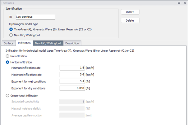
Figure: The ‘Infiltration’ tab in the ‘Land Uses’ editor
Note
Land uses on the catchment may also be modelled with the RDI hydrological model. In this specific case, the land use is described with a RDI parameter set instead.
Surface
In the 'Surface' tab, two types of initial losses can be applied to the land use:
- Wetting loss: this is a discontinuous loss, which happens as a first loss process. When precipitation starts, a part of the precipitation is used for wetting of the surface if the surface is initially dry. When wetting loss storage is filled, wetting loss process does not happen. It is not possible to infiltrate from wetting loss storage and the storage is recovered only by process of evaporation.
- Storage loss: this is the loss due to filling of the depressions and holes in the terrain. The model begins with the surface storage calculation after the wetting process is completed. The surface storage is filled only if the current infiltration rate is smaller than the actual precipitation intensity reduced by evaporation.
The roughness of the surface must also be specified with a Manning coefficient, which is a routing parameter. This Manning coefficient is only used in combination with the Kinematic wave (B) hydrological model to calculate the runoff of every individual surface / land use.
Infiltration
In the 'Infiltration' tab, three methods are available to characterize the infiltration for the land use:
- No infiltration
- Horton infiltration: this method is parametrized using:
- Minimum infiltration rate: infiltration rate at the end of the infiltration process.
- Maximum infiltration rate: infiltration rate at the start of the infiltration process.
- Exponent for wet conditions: a time factor that determines the dynamics of the infiltration capacity rate reduction over time during wet period. The actual infiltration capacity is made dependent of time since the rainfall start only.
- Exponent for dry conditions: a time factor defining the rate of the soil infiltration capacity recovery after a rainfall, i.e., in a drying period.
- Green-Ampt infiltration: this method is parametrized using:
- Saturated conductivity: hydraulic conductivity of fully saturated soil.
- Max soil moisture deficit: parameter describing how dry the soil can become.
- Average capillary suction: parameter describing capillary suction force as a head.
New UK / Wallingford
Losses are defined with different parameters for pervious and impervious land uses, as described below:
- Runoff volume type: this option controls whether the land use is an impervious area where runoff is computed as a fraction of the rainfall using the 'Fixed coefficient' method, or a pervious area where runoff is computed using the 'New UK' method.
- Initial loss porosity: this porosity defines the fraction of the initial loss storage depth which is available for rainfall storage. A value of 1 indicates that the loss storage depth is fully available for initial storage of rain, whereas lower values indicate that the storage is reduced due to filling with a porous material.
- Initial loss type: when the initial loss is defined as 'Absolute depth', the initial loss is defined solely by the 'Initial loss value'. When it is defined as 'Relative to slope', the actual loss is calculated as a function of the surface's slope.
- Initial loss value: the initial loss storage.
- Fixed runoff coefficient: this coefficient is only used when the runoff volume type is set to 'Fixed coefficient', and represents the fraction of the net rainfall which is converted into runoff.
- New UK depth: this depth is only used when the runoff volume type is set to 'New UK', and represents the soil water storage capacity.
Routing on the land use is controlled by the following parameters:
- Runoff routing type: the routing type can currently not be modified.
- Runoff routing value: the runoff routing value on the land use.
- Ground slope: the ground slope on the land use.
See the description of the 'New UK / Wallingford' hydrological model for additional descriptions.
Description
In this tab, a free description text can optionally be provided to describe the land use.
An optional surface type (Impervious / Pervious) may also be selected.