New UK / Wallingford
Introduction
MIKE+ supports modeling of storm runoff volume generated on catchments based on the concepts of Wallingford "Fixed runoff volume" for impervious surfaces and "New UK" loss model that accounts for infiltration loss and antecedent precipitation for pervious surfaces. This dependency on antecedent precipitation is modelled through the application of Antecedent Precipitation Index (API), which is dynamically updated during a simulation. The total runoff volume on a catchment is the sum of individual volumes computed on "Fixed runoff volume" surfaces and "New UK" surface defining the catchment.
This total runoff is routed with Wallingford routing method, developed for small urban catchments with area between 1000 m\(^2\) and 10000 m\(^2\). When applied for catchment sizes outside this range, the routing is identical as for these two limiting sizes.
This runoff model is activated for catchments with hydrological model type set to "New UK / Wallingford". This automatically opens the table for the selection of the available New UK / Wallingford "land uses" that define the various surfaces of the catchment with different runoff properties.
Any number of "Fixed runoff volume" land uses can be specified for a catchment using this hydrological model. The list of "Fixed runoff volume" land uses and their relative contributing area (percentage of the catchment area) are defined in the table. One and only one pervious land use with runoff type "New UK" can be specified for the catchment. It is selected below the table and it covers the fraction of the catchment which is not covered by the other land uses.
An example of a catchment definition for the New UK / Wallingford model is shown in the figure below. Note that three "Fixed runoff volume" land uses constitute the impervious part of the catchment, amounting in total to 60 % of the catchment area. The remaining 40 % is automatically allocated to the selected New UK land use.
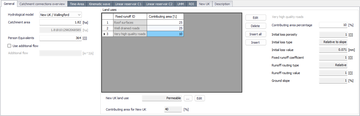
Figure: A catchment set up for New UK / Wallingford runoff model
The total sum of land uses' relative contribution is 100%, and this is automatically maintained by the program.
New UK / Wallingford land uses
Land uses are used to represent the various runoff surfaces associated with a catchment. These land uses are defined in the corresponding 'Land uses' editor, where land uses can be modified, added or deleted. Any land use can be selected and used in multiple catchments, so that a change in a single type of land use is applied to all related catchments.
The 'New UK / Wallingford' hydrological model uses properties of the land uses defined in the 'New UK / Wallingford' tab of the 'Land uses' editor. An example of land use definition is shown in the figure blow.
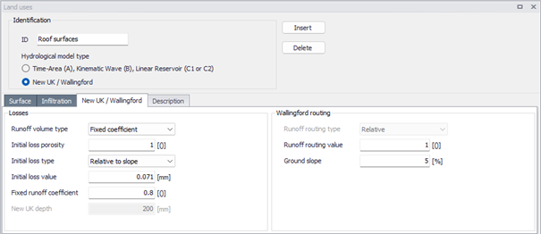
Figure: Example of definition of a "fixed runoff" land use for the 'New UK / Wallingford' hydrological model
In the following, the parameters and processes associated with 'New UK / Wallingford' land uses are described.
Initial loss and porosity
Both surfaces with "Fixed coefficient" and "New UK" runoff type include initial loss that accounts for wetting and depression storage (typically 0.5 - 2 mm). Initial loss represents the maximum water depth on the surface before start of runoff.
In continuous simulation, depression storage is dried out by evaporation during dry periods between rains.
Initial loss can be defined as an absolute depth [mm] or as a depth relative to surface slope. In the latter case, the actual loss is calculated as:
D = Value / 
Where:
D [mm] = depression loss
S [1/1] = surface slope
Recommended default values are 0.000071 (for impervious surfaces) and 0.00028 (for pervious surfaces).
Normally, the initial loss storage depth is fully available for rainfall storage. In special cases (e.g. porous pavement), this storage may be filled with a porous material, which reduces the actual storage capacity. This is controlled by specifying the 'Initial storage porosity' fraction.
Runoff volume on 'Fixed coefficient' surfaces
Runoff generated on impervious land use surfaces, directly connected to drainage network, is controlled by the 'Fixed runoff coefficient'. This coefficient represents the drainage efficiency and depends on the type of impermeable surface. The actual runoff volume from this type of impervious land use is calculated by linear scaling of the actual net rainfall volume with this coefficient, as: $$ \text{Runoff} L{3}T \% $$} = \text{Catchment area} L^{2} \cdot \text{contributing area} \% \cdot \text{Net rain intensity} LT^{-1} \cdot \text{Drainage efficiency
Recommendation includes four types of "standard" surfaces with respective efficiency of drainage:
| Surface type | Efficiency (%) |
|---|---|
| Normal urban paved surfaces | 60 |
| Roof surfaces | 80 |
| Well drained roads | 80 |
| Very high quality roads | 100 |
Table: Standard efficiency values for selected surface types
The values in the table above have been obtained by field measurements and are recommended to be modified only as part of calibration process.
It is possible to create and use any number of land use surfaces with various drainage efficiency, as appropriate.
Note
If there is an impervious part of a catchment that is not connected to the network and does not contribute to the drainage processes included in the model, it can be set up with a 'Fixed coefficient' land use, with zero drainage efficiency.
Runoff volume on 'New UK' surfaces
Runoff volume from pervious surfaces depends on the soil water storage capacity S, also called 'New UK depth', and on the current value of antecedent precipitation index (API). API represents the actual moisture content in the soil.
\(\text{Runoff } (L^{3}T^{-1}) = \text{ Catchment area } [L^{2}] \text{ * contrib. area } [\%] \text{ * Net rain intensity } [LT^{-1}] \text{ * API/S}\)
In turn, API depends on Initial API (or \(API_{30}\)), the current rainfall and the soil type, represented by decay coefficient K.
Initial API is supplied as a catchment property, and it is applied for any simulated runoff event.
When simulating design rainfalls, Initial API is specified as wanted, to describe the desired catchment's initial conditions. When simulating recorded rainfall events or a continuous rainfall time series, Initial API is calculated by a standardized procedure (not supported by MIKE+), on the basis of precipitation recorded in the 30 days preceding the simulation start date, and decay factor K.
The soil is categorized in five classes represented by soil index values (from 1 to 5). Soil index 1 stands for a light (sandy) soil that quickly recovers its infiltration capacity, while the soil index 5 is a very heavy (clayey) soil with a very slow recovery. Each soil category has a corresponding decay coefficient K, as shown in the table below.
| Soil Index | K (1/day) |
|---|---|
| 1 | 0.1 |
| 2 | 0.5 |
| 3 | 0.7 |
| 4 | 0.9 |
| 5 | 0.99 |
Table: Soil decay factors for the various soil indices
The values for soil moisture capacity S and decay factor K must be specified in the 'New UK' tab of the Catchments editor, according to the actual soil properties for the modelled catchment.
Note
In MIKE+, the catchment's soil category is represented directly by the decay coefficient K, rather than by the soil index. When imported from ICM software, the catchments' soil indexes are automatically converted to coefficient K, as per tabular values above.
During the simulation, the soil moisture conditions in a catchment, represented by API, are continuously changing due to the ongoing rainfall and soil moisture decay process. Consequently, runoff from the 'New UK' pervious surface is changing.
MIKE+ updates API during the simulation by accounting for two simultaneous processes:
- decreasing API due to recovery of the soil's storage capacity, depending on the soil type (defined by parameter K). The decrease of API between time t-1 and actual time t is calculated as:
- \(API_{(t)} = API_{(t-1)} \cdot K^{(dt/24)}\)
- increasing API due to ongoing net rain (i.e. rainfall reduced by evapotranspiration):
- \(API_{(t)} = (P - E) \cdot K^{(dt/48)}\)
Net rainfall that is not converted into direct runoff from impervious surfaces is assumed to flow into the pervious part of the catchment represented by the 'New UK' land use, where it contributes to increased runoff from the pervious part.
This contribution from each impervious surface amounts to: \(\text{Runoff } (L^{3}T^{-1}) = \text{ Catchment area } [L^{2}] \text{ * contrib. area } [\%] \text{ * Net rain intensity } [LT^{-1}] \text{ * API/S * (100 - Drainage efficiency) } [\%]\)
The total runoff from the pervious surface is calculated as a sum of all contributions from impervious surfaces and the contribution from the pervious surface itself.
Note
If the pervious surface in a catchment is not connected to the drainage network, (i.e. does not contribute to drainage system loads), it should be given a very large soil depth, so that API remains sufficiently low to generate insignificant runoff.
Runoff routing
Runoff from both 'Fixed coefficient' (impervious) and 'New UK' (pervious) land uses is routed by the Wallingford routing method.
This is a double quasi-linear reservoir, with two linear reservoirs is series, for each surface type, with equivalent storage-output relationship for both reservoirs: S = kq
Where S is the storage volume, q is the discharge and k is defined using the equation below: \(k = a \cdot C \cdot i^{*-0.39}\)
Where a is the 'Runoff routing value' defined in the 'Land uses' editor, and \(i^*\) defined using the equation below: \(i^* = 0.5(1+i_{10})\)
Where \(i_{10}\) is a running 10-minute average of rainfall intensity.
The value of C has been derived by optimization for a series of small catchments, and a generalized relation, including the surface slope and the surface area, has been established: \(C = 0.117 S^{-0.13} A^{0.24}\)
Where:
S = slope [m/m] (minimum acceptable slope is 0.002)
A = the area of the surface.