Land Uses
Land Uses are categories of activities or land surfaces that are assigned to catchment areas. Examples of land use activities are residential, commercial, industrial, and undeveloped. Land surface characteristics might include roof tops, lawns, paved roads, undisturbed soils, etc. Land uses are used solely to allow spatial variation in pollutant buildup and washoff rates.
There is complete freedom in defining land uses and assigning them to catchment areas. One approach is to assign a mix of land uses to each catchment, in which case all land uses in the catchment will have the same pervious/impervious characteristics. If this is not appropriate then it is possible to create catchments that have just a single land use classification along with a set of pervious/impervious characteristics reflecting the classification.
The following processes may be defined for each land use category:
- Pollutant Buildup
- Pollutant Washoff
- Street Sweeping.
The SWMM Land Uses editor organizes the land use data into the following groups:
- Identification: Land use item identification information.
- General: Associated street sweeping parameters.
- Buildup: Pollutant buildup characteristics.
- Washoff: Pollutant washoff parameters.
- Description: Optional descriptive information for land use item.
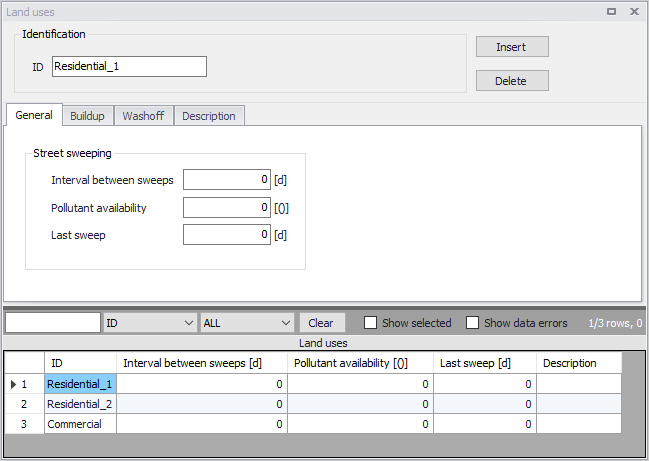
Figure: The SWMM Land Uses Editor
Identification
The Identification group box holds land use item ID information. Use the Insert or Delete buttons to add or remove records from the editor, respectively.

Figure: The Land Uses editor Identification group
| Edit field | Description | Used or required by simulations | Field name in datastructure |
|---|---|---|---|
| ID | Land use item ID | Yes | MUID |
| Description | Optional description for land use item | No | Description |
Table: Edit fields in the Land Use Identification group and Description tab (mss_Landuse)
Add optional descriptive information about land use items via the Description tab page of the editor. The page also includes an option for adding images of the land use item.

Figure: The Land Uses editor Description tab
General
Define land use parameters related to Street Sweeping, which affects the buildup of pollutants in areas.
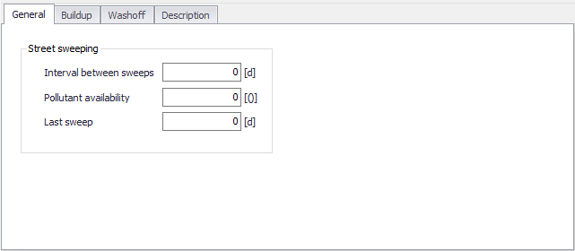
Figure: The Land Uses General tab
| Edit field | Description | Used or required by simulations | Field name in datastructure |
|---|---|---|---|
| Interval Between Sweeps | Days between sweeping | Yes | SweepInterval |
| Pollutant Availability | Fraction of pollutant buildup available for removal by street sweeping | Yes | Availability |
| Last Sweep | Days since last sweeping at start of the simulation | Yes | LastSweep |
Table: Edit fields in the Land Uses General tab (mss_Landuse)
Buildup
Pollutant Buildup that accumulates over a category of Land Use is described by either a mass per unit of catchment area or per unit of curb length. The amount of buildup as a function of days of dry weather can be computed using one of the following functions:
Power Function
Pollutant buildup (B) accumulates proportional to time (t) raised to some power, until a maximum limit is achieved:
(8.1) 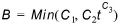
where C1 = maximum buildup possible (mass per unit of area or curb length), C2 = buildup rate constant, and C3 = time exponent.
Exponential Function
Buildup follows an exponential growth curve that approaches a maximum limit asymptotically:
(8.2) 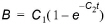
where C1 = maximum buildup possible (mass per unit of area or curb length) and C2 = buildup rate constant (1/days).
Saturation Function
Buildup begins at a linear rate which proceeds to decline constantly over time until a saturation value is reached:
(8.3) 
where C1 = maximum buildup possible (mass per unit area or curb length) and C2 = half-saturation constant (days to reach half of the maximum buildup).
Define pollutant buildup parameters for land uses on the Buildup tab page of the Land Uses editor. The list of pollutants for which to define parameters is based on pollutant items defined in the Pollutants editor. The following options are available for describing buildup processes for land uses:
- No Buildup
- Power
- Exponential
- Saturation
- Time Series. This option allows one to use a Time Series to describe the rate of buildup per day as a function of time. Define Time Series items in the Time Series editor with values expressed as mass per unit area (or curb length) per day.
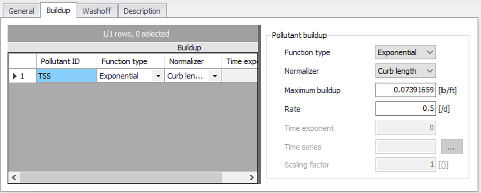
Figure: The Land Uses Buildup tab
| Edit field | Description | Used or required by simulations | Field name in datastructure |
|---|---|---|---|
| Function Type | Choice of function tpe to use for Buildup computations: No Buildup Power Exponential Saturation Time Series | Yes | FuncTypeNo |
| Normalizer | Choice of normalizer to describe pollutant buildup in either mass per unit catchment area or mass per unit of curb length: Area Curb Length | Yes If Function <> No Buildup | NormalizerNo |
| Maximum Buildup | Coefficient C1 (Maximum buildup possible in mass per unit area or curb length) | Yes If Function <> No Buildup | C1 |
| Rate | Buildup rate constant | Yes if Function is Power or Exponential | C2 |
| Time Exponent | Time exponent in Power Fuction | Yes if Function is Power | C3 |
| Half-Saturation Time | Half-saturation constant (days to reach half of the maximum buildup) | Yes if Function is Saturation | C3 |
| Time Series | Time series containing buildup rates. Define values in mass per unit area (or curb length) per day | Yes, if Function is external time series | ExternalTimeSeriesID |
| Scaling Factor | A scaling factor used to adjust buildup rates listed in the time series | Yes, if Function is external time series | C2_Scalingfactor |
Table: Edit fields in the Land Uses Buildup tab (mss_Buildup)
Washoff
Pollutant Washoff from a given land use category during wet weather periods can be described in one of the following ways:
Exponential Washoff
The washoff load (W) in units of mass per hour is proportional to the product of runoff raised to some power and to the amount of buildup remaining:
(8.4) 
where C1 = washoff coefficient, C2 = washoff exponent, q = runoff rate per unit area (inches/hour or mm/hour), and B = pollutant buildup in mass (lbs or kg) per unit area or curb length. Washoff mass units are the same as used to express the pollutant's concentration (milligrams, micrograms, or counts).
Rating Curve Washoff
The rate of washoff W in mass per second is proportional to the runoff rate raised to some power:
(8.5) 
where C1 = washoff coefficient, C2 = washoff exponent, and Q = runoff rate in user-specified flow units.
Event Mean Concentration
This is a special case of Rating Curve Washoff where the exponent is 1.0 and the coefficient C1 represents the concentration of any and all runoff in mass per liter (the conversion between user-specified flow units used for runoff and liters is handled internally by SWMM).
Note
In each case, buildup is continuously depleted as washoff proceeds, and washoff stops when there is no more buildup available.
Washoff loads for a given pollutant and land use category can be reduced by a fixed percentage by specifying a BMP Removal Efficiency which reflects the effectiveness of any BMP controls associated with the land use.
Define pollutant washoff parameters for land uses on the Washoff tab page of the Land Uses editor. The list of pollutants for which to define parameters is based on items defined in the Pollutants editor. The following options are available for describing washoff processes for land uses:
- No Washoff
- Exponential
- Rating Curve
- Event Mean Concentration
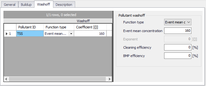
Figure: The Washoff tab page on the Land Uses editor
| Edit field | Description | Used or required by simulations | Field name in datastructure |
|---|---|---|---|
| Function Type | Option for describing washoff process: No Washoff Exponential Rating Curve Event Mean Concentration | Yes | FuncTypeNo |
| Coefficient | Washoff coefficient | Yes If Function is Exponential or Rating Curve | C1 |
| Exponent | Washoff exponent | Yes If Function is Exponential or Rating Curve | C2 |
| Cleaning Efficiency | Street sweeping removal efficiency in percentage | Yes If Function <> No Washoff | SweepEfficiency |
| BMP Efficiency | Removal efficiency of BMP controls associated with land use expressed in percentage | Yes If Function <> No Washoff | BMPEfficiency |
| Event Mean Concentration | Washoff pollutant concentration in mass per liter | Yes If Function = Event Mean Concentration | C1 |
Table: Edit fields in the Washoff tab (mss_Washoff)